May 22, 2017
A Day in the Life of an Archaeologist
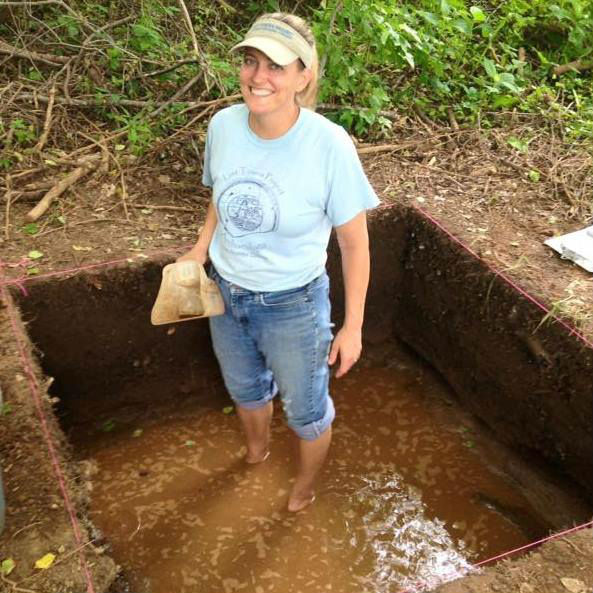
When you think of archaeology, you may not think of new artifacts being found all the time here in Maryland. But according to our guest, Director of Archaeology for Anne Arundel County Stephanie Sperling, there may be things worth digging up in your backyard! Stick around as we learn about a day in the life of a Maryland archaeologist. We’re covering everything from Stephanie’s favorite finds like a 10,000 year old Native American site and a forgotten 20th century baseball field to the technology used in the field today and why an archaeologist won’t go anywhere without her trowel. Get the dirt out of your ears for this episode of PerserveCast!
Guest:
Stephanie Sperling
Sponsor:

SUBSCRIBE


FOLLOW


Introduction
[Nick Redding] I’m Nick Redding and you’re listening to PreserveCast. Apart from Indiana Jones, what does an archaeologist actually do? It turns out that a lot of archaeologists like this week’s guest, Stephanie Sperling, work a little closer to home than you might even expect. We’ll learn about Stephanie’s work in Maryland’s Anne Arundel County on everything from prehistoric Native American sites to colonial settlements and more. Let’s start digging in to this week’s PreserveCast.
From Preservation Maryland Studios in the historic podcast district of Baltimore, this is PreserveCast!
[Nick Redding] This is Nick Redding and you’re listening to PreserveCast. Today we are joined in studio by Stephanie Sperling, who is the director of Anne Arundel County Archaeological Research. That is a county here in Maryland along the Chesapeake Bay and Stephanie has been working in the Chesapeake region for eighteen years. And so we’re having her here in the studio today to talk about all things archaeology. So, it’s good to have you here.
[Stephanie Sperling] Thank you so much for having me. I’ve become a real fan of the series. I’m jazzed to be here.
[NR] Cool! That’s really great. That’s good to hear. So we always try and dig a little bit deeper. We’ll try and use every archaeology pun we have –
[SS] Please do.
[NR] – in the book today. So we want to dig a little deeper and find out how you found your way to archaeology. So we ask people how they get into those different niches within preservation. So how did you become an archaeologist?
[SS] Growing up I was always interested in history. I loved history. It was my favorite subject in school. And my favorite thing to do in my free time was wander in the forest just to play in the woods. And when I would be back there I’d often find stuff that people had left behind, old bottles or whatever. And I always asked questions, “Where did this come from? Who left it? What did this place used to look like? How did it get here?”
So when I got to college, I kind of flitted through a couple of majors and eventually I landed in anthropology. [I] loved my archaeology classes, and it was just tying back everything I’d loved as a kid. So after I graduated, my first job in archaeology was at Jefferson Patterson Park and the Maryland Archaeology Conservation Lab down in Calvert County. It’s the Maryland State repository for artifacts. So if you’ve dug a site anywhere in Maryland, this is the place your artifacts can go. So I got a job there. I worked there for a year and worked on some amazing sites, contact period sites, when the Europeans were first arriving here and they met the Native Americans. So I learned field techniques there. I learned how to work in the lab what happens to all the artifacts after you find them. I learned how to talk to people about archaeology and outreach and I was just hooked so I’ve been doing it ever since.
[NR] And so your next job would’ve taken you to Anne Arundel County, is that the progression there?
[SS] No. For several years after that, I worked in CRM, in cultural resource management. Most archaeologists in this country are employed as CRM archaeologists. It’s the business side of archaeology. So you work for a firm that is hired in advance of construction. So if they’re going to be putting in a road or they’re putting in townhouses and there’s federal or local regulations that require archaeology, they’ll hire you and you’ll go and you’ll do a survey first, and look for the sites, and eventually mitigate them if they can’t avoid them before they develop. So I did that for several years.
[NR] Did you travel around the country doing that? Or was it all here in Maryland?
[SS] No, all in the middle Atlantic. Most of that time was spent out in northern Virginia. It was the early 2000’s and there was a big construction boom. And all of the counties in northern Virginia have local regulations that require archaeology, so I was kept employed and got to home every night. The flip-side of that, though, was that it wasn’t terribly interesting archaeology a lot of times. It was a 600-acre tract of land that we had to go and dig thousands of little holes looking for artifacts and often you’d find nothing except ticks and cedar forest hell [laughter].
[NR] So you really enjoyed your time in Virginia, I can tell.
[SS] You know, I learned a lot. I expanded my network. Archaeology is a small profession so I got meet a lot of people. Like I said, I learned a lot. But after several years of that is when I was offered the job working in Anne Arundel County, and I’ve been doing it ever since because it’s more research driven and it’s more outreach driven and that’s what I really like about it.
[NR] So, for people who aren’t familiar, maybe they’re listening from somewhere else in the country, how would you describe Anne Arundel? What is Anne Arundel County? What’s the history and what kind of things can you expect to find as an archeologist there?
[SS] Anne Arundel is located on the Chesapeake Bay; it’s on the western shore of the bay. We have over 500 miles of shoreline so the county has always been very water-focused. The type of sites that I’ve been digging, particularly over the last seven or eight years, have been coastal sites – Native American coastal sites. First European settlers to Maryland in the 1600s lived close to the water so that they could ship out the tobacco and the different goods that they were manufacturing. Then it became a watermen type place where people fished and there were wharves. Later on, it became a place for recreation, so I’ve excavated a lot of coastal sites that are beach resorts, and steamship wharves, and places that people from Washington and Baltimore came and they made this their playground before the Bay Bridge came –
[NR] Because for those people who maybe aren’t for Maryland, before we had the big Bay Bridge that spanned the Chesapeake Bay, a lot of the sort of recreation in the summer took place on the Western Shore versus going over to the Eastern Shore. Or even if you went to the Eastern Shore, you went to beaches right on the edge. You didn’t go all the way to the ocean because that was a real trip back then, I guess, before the age of the automobile.
[SS] Exactly. Exactly. So there were some steamships that would take you from Baltimore to the Eastern Shore, but they were just day trips, so maybe –
[NR] You came back.
[SS] – you came back.
[NR] Tolchester Beach I think is one up in Kent County, Maryland.
[SS] So then after Anne Arundel kind of lost its appeal as a recreation destination, we have a lot of people that drive to Washington and Baltimore for work. It’s suburban, but there’s some rural parts. I live in a very rural part of southern Anne Arundel County, where I have to drive twenty minutes to get to the grocery store.
[NR] That’s pretty rural.
[SS] Yeah [laughter]
[NR] And also, people should know too that Annapolis falls within Anne Arundel County, so it is also the capital of the state falls there, as well.
[SS] It’s the capital of the state and the capital of our county, so yeah, there’s a lot going on in Annapolis.
[NR] Pretty exciting. So as an archaeologist, for someone who is totally brand new to archaeology – they didn’t understand what it was at all… First off why do you do archaeology? Let me take the counter-point. You’re just digging things up. They’re old things. What does it matter if you find an arrowhead? Why should we care about archaeology? Let’s try and find that answer first.
[SS] [laughing]
[NR] And then maybe we can walk through how it actually works, but why?
[SS] So archaeology gives us a way of looking at the past and engaging with the past that is unique. You can read about history in a book. You can go to a historic house and imagine what life must have been like, but archaeology is… it’s unbiased in a way. Everybody leaves an archaeological site behind. I mean what I do is I dig through people’s garbage from a long time ago, but this can be exceptionally revealing. I can find out things about you. I can find out what you like to eat. I can find out where you were. I can find out what type of person you were. I can certainly find out when you occupied this area. And when you can pick up an artifact, you’re reaching out across time.
[NR] Right. Because often times you’re the first person to touch that since it was dropped, right?
[SS] Sure, absolutely.
[NR] So in the cases of pre-settlement, you’re talking about maybe thousands of years?
[SS] Thousands of years. The earliest site that we have in Anne Arundel, is probably [12,000] or 13,000 years old, so we’re talking about a time – it’s almost unimaginable how ancient it is. So absolutely. I mean archaeology also gives us a way of understanding people for whom there was nothing ever written. There is no written record because everybody does leave the site behind. So you can learn about women, children, slaves, tenants, just everyday people through excavating archaeology sites.
[NR] So really, it kind of gives voice to the voiceless in some ways. It’s the unwritten history, but it’s no less important than a journal or the structure that’s still standing.
[SS] Sure! And it’s always great when you can dig a site that is a historic period site, that’s from when we do have writing because then you can kind of put together what you’re finding in the ground plus the written record and that can paint a very vibrant picture of the past.
[NR] Now, I guess I should have asked this. Do you consider yourself a historic-period archaeologist or a prehistoric? Is there a distinction between the two? Is it sort of like you guys fight each other?
[SS] [laughing]
[NR] Do you have to kind of say, “Okay, this is what I’m going to do,” and then you just go that way your whole career, or can you do both? How does it all work?
[SS] I certainly have done both and appreciate both. I suppose when I started my career I really trended more towards historical archaeology because it seemed so much more tangible. When you look at a collection that somebody left behind from 1800, you can kind of get, “Okay, these are dishes. These are silverware,” as opposed to looking at a collection of ancient Native American artifacts, which are like, “These are rocks” and what else do you have?
But throughout my career, especially in the last several years since I’ve been with Anne Arundel, I’ve done a lot more prehistoric of ancient Native American sites, which I find just fascination. Because like we kind of alluded to, there is nothing written about these people and here in Maryland these cultures that had existed for thousands and thousands of years were wiped out and nearly wiped out by 1700. For us to understand what the Indians were doing, you have to look through the lens of archaeology especially when you’re getting back into the long ago.
[NR] Well, there are so few Native Americans left to this day. I mean I grew up in western New York, and there we still had Native American reservations and some family members are Native Americans. And there it was just so much more even ingrained into modern-day society that that was an aspect of life, and there was sort of this continuum from the prehistoric period in a way, right? I mean, these people were still living there and still had these connections. But in Maryland there are obviously still some tribes left, but they are so few and far between that I feel like archaeology plays an even more important role in an area where the native people have just been kind of removed from the landscape.
[SS] And removed from memory. I mean –
[NR] Right. Yeah, there’s no societal memory of it.
[SS] Exactly. In an area like Maryland there’s no cultural continuity, right? I mean it’s in New York or if you go out West or go to a place like Hawaii or some place where the native groups are still there and still part of the conversation. But here I mean when kids are taught about Maryland history, there might be a half a chapter at the beginning of the year talking about, “Oh, Indians lived here for 10,000 years and now let’s start at 1600 and move forward.” So yeah, it’s filled in a lot of our gaps but I mean, of course, the problem with archaeology and the problem with looking back through the record is that there’s not much that lasts for that long. So we’re trying to make these huge leaps of understanding of what life was like thousands and thousands of years ago for a culture that we have nothing to directly relate to.
[NR] Right, and archaeology is a science. So trying not to do too much conjecture, as well, right? I mean you’re kind of –
[SS] [laughing]
[NR] – there’s a little bit of it. It’s maybe not the hardest of sciences, but in a sense you are trying to match things up with fact and basis in artifacts, I guess.
[SS] Oh, absolutely. We dig stratigraphically down through the layers. We dig very intentionally and scientifically and do utilize different scientific processes to inform our analysis, ultimately. But in some cases, you’re making big leaps of faith. And then, of course, you dig the next hole and everything that you thought you knew is gone.
[NR] Well, I think that’s a good segue to talking about – you’re talking about stratigraphic digging and all those sorts of things. I think that that’s a great segue to kind of talk about how a dig actually takes place and all that sort of thing. Why don’t we do that after we take a quick break? And we’ll be right back on PreseveCast.
Maryland: Mini-America
[Michelle Eshelmen] Alright Steve, it’s Maryland quiz time.
[Stephen Israel] Bring it on! I know all the Maryland facts there are to know.
[ME] I bet you won’t know this one. I’ll even give you multiple choice. Who was Astrodon Johnstoni? A) the state dinosaur; B) a famous Mid-Atlantic rockstar; or C) the first Marylander to walk on the moon?
[SI] Ha, I see what you’re doing. That’s a trick question. It’s B and C. Astronaut Bon Jovi is a rock star who walked on the moon.
[ME] Come on, Steve. I said Astrodon Johnstoni; and Bon Jovi is from New Jersey.
[SI] So it’s A? Maryland has a state dinosaur?
[ME] Yes. Astrodon Johnstoni is actually the first dinosaur discovered in Maryland and the first sauropod discovered in the country. Phillip Tyson, the state agricultural chemist, found a pair of teeth in 1858 near Meerkerk in Prince George’s County. He wasn’t sure what to do with them so he brought the teeth to Doctor Christopher Johnston, a local physician and dentist. Johnston cut a very thin slice into the tooth to examine it under a microscope and found an unusual star shape in the cross-section of the tooth. Because of this shape, he referred to whatever creature they came across as astrodon or startooth, in an article he wrote for a dental journal in 1859. In 1865 Dr. Joseph Leidy, often considered the pioneer of American paleontology, examined the finds and was able to make a complete description and gave it the full scientific name of Astrodon Johnstoni.
[SI] So you really were trying to trick me. Because it sounds like you’re saying that dinosaur’s name is really Startooth Johnston?
[ME] I guess you could say that, Steve. Anyway, enough prehistory. Let’s get back to PreserveCast!
Do you have questions? We may have answers. If at any point during this podcast you’ve thought of a question that you have for us or maybe one of our guests, we’d love to hear about it. You can send an email to podcast@presmd.org and we’ll try and answer it right here on the air on the next episode of PreserveCast.
[NR] This is Nick Redding, and you’re listening to PreserveCast. We’re joined in studio today by Stephanie Sperling, who is the director of Anne Arundel County Archaeological Research and we are talking about all things archaeology. Before we took our break, Stephanie sort of opened up about stratigraphic digging, and how a dig takes place, and what they find, and how it can blow up different assumptions when all that happens. And I thought this would be a good opportunity to kind of go step-by-step through, if you didn’t know anything about it, how would you explain how an archaeological dig works? So you’ve got a piece of property someone, for some reason or another either because of a law has been triggered or they’re just fascinated by – they think there’s some history there and they want to do an archaeological dig, what happens then?
[SS] Well, the first step is – before you even start, you want to do some background research. So we will use GIS to look at historic map overlays. We’ll go back as far as the historic maps go for that area, sometimes it’s 100 years, sometimes it’s 200 or 300 years or more, and see if there was ever a house or a dwelling or something that was there on that property. And we could also use LiDAR to see what’s going on beneath the tree canopy.
[NR] Why don’t you tell us what LiDAR is?
[SS] So LiDAR’s just a technology that enables us to see what the ground surface looks like without the trees, without the buildings on it. So if I’m going to go out and walk around a property I want to know are there big depressions? Maybe that’s where a cellar was. Could I be so lucky there are huge terraced gardens or something? I did a project recently where we had these amazing terraced gardens that just popped out on the LiDAR maps. You could see –
[NR] Oh, so you didn’t see them – you didn’t know that they were there before the LiDAR?
[SS] No, not really. Not really.
[NR] Wow. That’s pretty cool.
[SS] I mean, we sort of knew there was a hillside there.
[NR] Where was that?
[SS] It’s called Ivy Neck Plantation. It’s an 18th-century plantation on the Rhode River south of Annapolis.
[NR] Maybe we can get a picture of the LiDAR for the blog that will accompany this –
[SS] Oh sure.
[NR] – podcast.
[SS] Sure.
[NR] That sounds pretty neat.
[SS] Yeah, that was a really neat site. And that was a Phase I, we call it, the first step in –
[NR] Okay. So why don’t you take us through that project then? Why don’t you tell us how that all came together? So you did your research on it. You’ve done your LiDAR. And then what happens at this plantation site?
[SS] We went out and, first of all, we do a walk-over. We walk around the entire property and try to get a sense of the landscape. Are there any ruins that are still left on the surface? At Ivy Neck there’s a huge mansion. We knew it was there. It was built in the 1780s and burned in the 1940s, burned to the ground. So that was still there. But then we’re also looking around for any kind of outbuildings to get a sense of what the landscape looked like. In that case, we got our county survey crew to come out and they used their total station to map in all of the surface features, all of the roads. They mapped in the terraces. It’s on a bluff overlooking the river and so they mapped in the edge of the bluff because part of the reason we were out there was because we’re monitoring coastal sites to see what sites are eroding and susceptible to sea level rise. And this one’s eroding. The cliff’s eroding pretty quickly. So we wanted to get a baseline for where it is now so we can keep an eye on it. So then we just dig a bunch of holes
[NR] And that’s called a phase one, right?
[SS] This is a phase one, yeah. A phase one identification. We’re identifying a site. I suppose we sort of knew the site was there, but no survey had ever taken place out there.
[NR] And how far apart are these holes and how big are the holes?
[SS] In this case, it was 25 feet.
[NR] So each hole is 25 feet apart?
[SS] Yep. And we dig them about a foot, foot and a half in diameter. And we dig down, oh, as deep as you go to don’t find stuff anymore, which is sometimes like a foot to two feet deep.
[NR] Okay, and so how is this digging done? Is it done –
[SS] With a shovel.
[NR] Shovel, but is it delicate, in a Phase One?
[SS] Oh, no.
[NR] Not delicate.
[SS] Oh, no, no.
[NR] You’re just throwing things around.
[SS] You are just pounding through the earth, trying to bust through the roots. I mean, archaeology is tough work. It’s tough, physical work, you know? And then, so you’re just taking the shovel and you’re digging a hole with the straightest sides as you can, so you can see what the soil profile looks like, ultimately. You take all that soil and you push it through a screen, a one-quarter-inch mesh, and once you push all the dirt through, you can see if there’s any artifacts left. You record what the soil horizons look like, because that can help us figure out how old is this? Where did all the artifacts come from? We can take a look at the soil. It kind of gives us an opportunity to see beneath the ground surface in a broad way. And we record all the soil, we record the artifacts we found, and then you move on to the next one.
[NR] And how many of those did you do on this site, give or take?
[SS] At Ivy Neck, I think it was about 100. But some of the surveys I was talking about earlier in northern Virginia, there would be thousands. Thousands and thousands of little holes dug in the woods.
[NR] Wow. So, ideally, you find something in one of these [laughter]. Did you find anything at Ivy Neck?
[SS] You know, at Ivy Neck, interestingly, we did not find very much in the shovel tests –
[NR] Aw, that’s a sad story.
[SS] Well, but it’s not – it has a happy ending [laughter].
[NR] Oh, okay.
[SS] At Ivy Neck, we didn’t find much in the shovel tests because the owners still live on the property, and so they’ve kept it pretty clean. There’s not a lot of that trash that’s laying around. But when we got inside the mansion, we were able to crawl around in some of the cellars that were still there from the old mansion and found what is probably the owner’s private collection of projectile points of arrowheads that they had picked up over the years from their farm fields. And when the house burned, they clearly just forgot about it. I mean, they took most of their furniture out, they took the big stuff out, but they forgot about this little collection of projectile points. So we found hundreds and hundreds of Indian arrowheads –
[NR] That probably came from that property.
[SS] They absolutely did. Actually, on the property as well, there’s an Indian burial ground that has eroded into the Rhode River, maybe fifteen or twenty years or so ago. But it was a really significant burial ground. Very, very unusual; like, 2,000 years old. So we know the Indians were coming there for a long time before the settlers got there.
[NR] So let’s say, though – maybe Ivy Neck’s not the perfect case – but a situation where you do find something pretty significant during this Phase One process. Then what could potentially happen? You move on to a Phase Two?
[SS] So at a Phase Two level we’re evaluating the site. So let’s say that a developer is going to put a road in. And so we’ll say, “Alright. We found a site at the Phase One level. But now we want to go out and evaluate it. We want to see it. Is it eligible for listing on the register, on the National Register of Historic Places? Does it retain integrity?” is the question we’re always asking. And when you’re talking about archeological integrity, it’s like, “Is it still intact?” or “Did I just find all this stuff on the surface?” or “Are there intact layers? Are there things for me still to find beneath the ground surface or has it been destroyed?” And in order to do that, we start to dig units. So they’re squares, sometimes three feet across, sometimes five feet across. And we dig them layer by layer.
[NR] And this is more delicate than – ?
[SS] This is a little bit more delicate. Yeah, we start out with shovels and then we’ll move to trowels. And we scrape away the layers of soil. We’re still screening. We’re still looking for artifacts. And then if we find stuff, if we find intact features or, like, pits or hearths or foundations or something that’s still intact beneath the ground surface, we’ll tell the developer, “Can you move your road because we really want to preserve this site?” And if he says, “No, I still have to put my road through there.” Then it moves on to Phase Three, which is full data recovery. We will excavate the site out of existence because it’s going to be destroyed anyway. So we’re trying to recover as much information as we can.
[NR] So if you can save it, though, if the developer does move the road or doesn’t put the house foundation there, then you would generally not want to move to a Phase Three to completely remove it? Is that the goal there? You wouldn’t want to completely remove it or is there – what’s the thought on that in archeology?
[SS] Yeah. The goal is – the goal is always to keep the site where it is. To avoid the site is always the number one recommendation. Now, that’s a little different in some of the work I’ve been doing with coastal sites.
[NR] Because you’re expecting you’re going to lose it?
[SS] Because we are losing them.
[NR] Because you are losing them.
[SS] I mean, here on the Bay, the rate of erosion for some coastal sites that we’ve observed is stunning. I mean, it’s 40, 50, 60 feet in just a matter of years.
[NR] Wow!
[SS] So we know that the site is going away. So in that case, what we’re trying to do is do that Phase Three level data recovery to get as much information as we can before it’s gone. But in a site that’s in the middle of a field or that’s not imminently threatened like that, we always recommend that they avoid them. And when we dig sites, we’ll often just – we won’t dig it all. We leave something for our future archeologists.
[NR] Just in case there’s new technology, perhaps, in the future.
[SS] One can only hope.
[NR] So speaking of that, what kind of technology are you using out in the field? So far, the technology we’ve heard has been shovel and trowel. I presume there – and I guess we got LiDAR in there and we got GIS –
[SS] And we got the Total Station.
[NR] And the Total Station. So there was some prep technology, right, in finding sites and things like that. And then documenting things out there with the Total Station and creating a map of what exists on a site. But when it actually comes to digging things out of the ground, is there anything more or just that come more in the backend in the lab?
[SS] It really comes in the frontend and the backend. I mean, the type of work that I’m doing now in the field is nearly the same as what I did when I started in this profession. In fact, I was thinking about this yesterday. I was out. We’re digging this site. It’s a seventeenth-century site, maybe 1660s to 1680 house site. So I’m getting ready to get into a feature, a big cellar feature. It’s full of bones, and shells, and pottery. Somebody’s going to build a barn in the area and so we’re out there trying to dig around it before they destroy it with the barn. And I was sharpening my trowel and this is the same trowel I got eighteen years ago. It –
[NR] Oh wow. Is this a thing in archeology, you hold on to your trowels?
[SS] Oh my gosh, yes. You do not touch someone else’s trowel.
[NR] Really? I had no idea. Wow.
[SS] Yes. You have to ask permission. My trowel and I – archeologists are very close to their trowel, yes. And mine has shrunk considerably over the years. That’s like –
[NR] Can we get a picture of your trowel as well?
[SS] Sure!
[NR] Has it ever had a photo shoot done?
[SS] I don’t think so.
[NR] You don’t have it on you, do you?
[SS] It’s in the car.
[NR] Well, you’re bringing it in [laughter]. After this, she’s bringing in this so we can get a picture of it.
[SS] Sure, sure.
[NR] All right. Do you always travel with it just in case?
[SS] Yeah.
[NR] Wow!
[SS] You never know.
[NR] I had no idea. This is illuminating.
[SS] You never know. I have my Munsell book in the car.
[NR] Okay.
[SS] It can read soil colors. I got my gloves. I got my field boots. I mean, just say the word, and I can… Well, we’ll go do some archeology here [laughter].
[NR] Okay. It sounds good. Alright, so you’ve got the trowel. But that kind of thing, you’re sharpening it and that’s been the way it’s been done for a long time, right?
[SS] Absolutely. I mean, and we still hand map. I’m still using – you can map using a total station. But archaeologists still really appreciate being able to map with rulers and graph paper because it gives you another way of looking at what you’ve excavated and thinking about what you’ve excavated.
[NR] Right. Because you’re having to actually commit it to paper and looking at it as you’re doing it, I guess.
[SS] That’s right.
[NR] But then, I guess, once it gets to the lab section, why don’t you tell us what happens in a lab? And it sounds like maybe there’s more technology taking place there.
[SS] There is to a certain degree. I mean, certainly, we still take the artifacts dirty back to the lab. Our lab is in Edgewater. The county archeology lab’s there – Edgewater, Maryland. And every one of those artifacts that we’ve found, we’d scrub with a toothbrush to get the soil off. But then, we start to analyze them. Now, here’s where technology starts to come into handy. It’s a lot of data sharing. If I find something – you know, artifacts are small. It’s a broken piece of something that was whole hundreds or perhaps thousands of years ago. So the ability to contact other archeologists to see what other archeologists have put online and then to put what we found online to compare, like, “What is this weird little object that I found?”
[NR] So that’s a lot easier now than perhaps it was before?
[SS] It’s tremendously easier, absolutely. You know, I know archaeologists that do 3D scanning.
[NR] Right. And we actually brought someone in who had done some 3D scanning with Direct Dimensions, which is a firm based here in Maryland. And they actually told us a story about 3-D scanning, something that had a thumbprint in it and they were able to pull that thumbprint off. This is over in Mesopotamia area in the Middle East and trying to kind of come up with, could there be a database of archaeological thumbprints to see how thing’s kind of traveled through trade through the world? So pretty intense. I mean, you can get really detailed, I guess, there.
[SS] Well, 3D scanning of artifacts also allows us to take these artifacts out on the road to give them to people to hand to people and to let them touch them and interact with them in a way that they wouldn’t be able to with the original object.
[NR] I guess, the final phase beyond the lab is exhibition of items. Does Anne Arundel County do that? Have you gotten involved in that at all or are you more just on the digging and science side of it?
[SS] No, I’m very much on the outreach side of it. We do have a museum at Historic London Town and Gardens that talks about some of the archaeology that has take place at London Town and across the county. So that’s one place we’ve been able to display a lot of our artifacts. Right now, we’re working on projects where going to be displaying some artifacts in different libraries across the county, but it’s also going to have iPad-type technology, touch-screen technology, where we can just hand this to groups of people and they can swipe through and see pictures of the dig and pictures of all the artifacts we’ve found and see some of our results. But the other thing that we try to do is bring archaeology to people who can’t go to a dig site. We always take volunteers and here’s my shout-out: please, come volunteer at the Anne Arundel County Archaeology Project.
[NR] Do you have a project this summer that’s coming… Normally, they’re done in the summer I presume?
[SS] Oh, no. All year.
[NR] All year?
[SS] Yeah.
[NR] You’re out in the winter?
[SS] Oh, yeah.
[NR] Oh, my.
[SS] Yeah.
[NR] Nobody wants to volunteer on that one though?
[SS] Only the hardy [laughter].
[NR] Easier to get them May, June, July, I guess?
[SS] Well, it’s hot.
[NR] Yeah, that’s true.
[SS] You know, it’s hot in the summer. I’d say the shoulder seasons are probably the best time.
[NR] Do you have any cool projects that you’re working on now that you’re looking for volunteers?
[SS] Well, Skipworth’s Addition is the project I was talking about earlier, the seventeenth-century site. We are in the middle of excavating it and taking people in. But the best way to find out what projects we have going on is to just go to the Lost Towns Project website, www.LostTownsProject.org and we have all of our volunteer opportunities listed there. You can come and dig on any site that we ever dig. If you want to do a Phase One level shell test survey or you want to dig squares into super cool Indian sites, I mean, we do it all and everything in between.
But the other thing we’re doing now is some outreach projects where we developed a series of hands-on archaeology workshops where we’re pulling all of the artifacts – collections of artifacts – out of the basement and showing people what we have. I mean, in the county, we hold millions of artifacts but a lot of them just sit in boxes kind of forgotten about. So we’ve developed projects where – the first one we did we called it Partying Through Time where we went back and thought, “How is partying reflected in the archaeological records?” So we had smoking and drinking and taverns and Indian feasts. We dug up a twentieth-century Negro League baseball field, and so we pulled out artifacts from that and showed people – they got to touch all this old stuff and just learn about the way that we interpret sites. We did another workshop recently at London Town where we showed people the artifacts that were dug up from London Town, showed them how we analyzed the sites, and then took them out to buildings that have been recreated there at the park based on the archaeology and then talked about, “Okay. So how did you go from this one shard of pottery
to this building that’s standing on the landscape and now how do you use that building as a way of bringing people into the past?”
[NR] Yeah, and I feel like in a sense, we’ve kind of come full circle to one of the first questions about, why does archaeology matter? Doing the public outreach reinforces that point because I think it’s easy for members of the general public who aren’t familiar with it perhaps to not see the value in it. But when you’re really confronted by those pieces, and you can connect in the same way that perhaps an archaeologist could in a pit, but if you don’t have the opportunity to do that I feel like that’s a way to really kind of make archaeology pop for the general public.
[SS] Thanks. I mean, most people are really fascinated by archaeology, but just have no idea that it exists here. So one thing that we really try to do in Anne Arundel is bring people into the process and let them know that we’re here, and we’re always looking for people to help us.
[NR] So speaking of digs, normally we ask people what their favorite historic structure is in Maryland or wherever they’re talking to us from, but because you’re an archeologist we suppose we’ll let it slide and you can tell us your favorite dig that you’ve ever been on because I presume you have one? Or it might be difficult to choose, but we’d love to know what it is that takes the cake?
[SS] It is really difficult to choose. As a fan of this podcast, I’ve been thinking about it: what is my favorite dig? It’s like picking your favorite child [laughter]. I mean, I’ve done some really cool ones. But I think I’m going to go with some of the sites I’ve dug in the Jug Bay area of the Patuxent River.
So the Patuxent River forms the western border of Anne Arundel County and starts up in Frederick. The Patuxent starts in Frederick and it goes into the Chesapeake Bay down at [Solomons Island]. So we’ve been digging about halfway up the Patuxent just finding some amazing Native American sites there, one of which was called Pig Point. Pig Point was an Indian village. We’ve proven that people have been living there for 10,000 years. We did radiocarbon dating on some ancient charcoal or maybe hickory nuts we found in a pit and we did radiocarbon dating and our dates went back to 730 B.C., which is about 9,000 years old, but we found artifacts underneath that pit so we know that people had been living there for 10,000 years. And we found where the outlines of their houses were. We found where they were having these ritual feasts we found where they were burying their dead in this really weird, bizarre way from like 200 B.C. to 200 A.D.
[NR] Now, do you still find bones?
[SS] Oh, yes. Yeah. There were bones. The remains of hundreds of individuals were still there. Another piece of technology that we’re using on the bones from Pig Point is isotopic analysis, where we’re going to be able to determine if the people that were buried there ate a lot of fish or if they didn’t eat a lot of fish. If we find that they did, then that can show us that they were coastal people. If they didn’t, then maybe they lived in the mountains or they lived farther inland because a lot of the artifacts that we find in these pits are from Ohio and from Michigan and from Pennsylvania. From far away, showing these vast trade networks that are taking place thousands of years ago. So are the people that are buried there locals or are they coming from far away? And the coolest thing about the Pig Point site is that when people think, “Oh, there’s nothing left to find in Maryland.” I mean, this is in people’s yards. There’s houses all around us. There’s roads and driveways. I mean, this is all what’s just beneath it.
And now we’ve been working on a site called River Farm for the last couple of years, which is a mile away from Pig Point. Trying to see how this little site – well, it’s not much of a little site, it’s a huge site actually on the floodplain – relates back to that. We’re seeing a lot of the same behaviors were taking place like 1,000 years ago, 2,000 years ago with the ritual feasts and the same type of materials and the same type of trade routes that are coming from thousands of miles away.
[NR] But separated from Pig Point by almost 4 or 5,000 years, right?
[SS] No, no. They were used at the same time.
[NR] Used at the same time. Oh, okay. Alright. But as you mentioned too though, this is – some of this is taking place in people’s backyards. So I guess someone listening right now, the likelihood that you have archaeological deposits in your backyard is probably high.
[SS] Is probably high. Absolutely.
[NR] It just depends on – they may not be 10,000 years old, but they’re probably pretty old.
[SS] Yeah.
[NR] That’s pretty cool.
[SS] There’s always the chance.
[NR] Yeah. Alright, Stephanie. If someone wanted to get a hold of you or wanted to learn more about the work that [you guys are] doing, why don’t you give us some contact information?
[SS] Sure. Well, if you want to find out about the work we’re doing, generally, like I said, go to the Lost Towns Project website, www.LostTownsProject.org. Or you can email me directly at pzsper64@AACounty.org.
[NR] Awesome. Well, thank you for coming in, answering questions, illuminating archaeology in many different interesting ways. Also giving us the background on the importance of the trowel for every archaeologist [laughter].
[SS] I’ll go get it right now!
[NR] I’m looking forward to it. And thank you for you do to preserve Maryland history. We appreciate it.
[SS] Thanks for having me.
[NR] All right. Sounds good. We’ll be back next time on PreserveCast.
Credits
You don’t need to open a history book to find us and available online from iTunes and their Google Play Store as well as our website: PresMD.org. This is PreserveCast.
This podcast was developed under a grant from the National Center for Preservation Technology and Training, a unit of the National Park Service. Its contents are the sole responsibility of Preservation Maryland and the Maryland Milestones Heritage Area and do not necessarily represent the official position or policies of the National Park Service or the National Center for Preservation Technology and Training.
This week’s episode was produced and engineered by Ben and Stephen Israel. Our executive producer is Aaron Marcavitch. Our theme music is performed by the band Pretty Gritty. You can learn more about them at their website: PrettyGrittyMusic.com, on Facebook, or on Twitter @PG_PrettyGritty.
To learn about Preservation Maryland or this week’s guests, visit: PreservationMaryland.org. While there, you can check out our blog and learn about what’s current in historic preservation. We’re also on Facebook, Instagram, Flickr, and Twitter @PreservationMD. And of course, a very special thank you to our listeners. Keep preserving.
Show Notes
Stephanie Sperling served as a internship advisor to Matthew Nickolson, a Preservation Maryland Waxter Intern, who worked closely with the Lost Towns Project on an archaeological dig and lab work as part of his degree program in Environmental Sustainability from the University of Baltimore. Matt’s research is available on the Preservation Maryland blog.
Previous episode