April 3, 2017
Architectural Documentation Best Practices with HABS/HAER
Who do you look to when you need historic places, vehicles and more documented on a national level? Well, the National Parks are at your Service! This week Nick spoke to the head of the Historic American Building Survey, Catherine Lavoie, as well as a representative from the Historic American Engineering Record, Dana Lockett. Learn about how Catherine and Dana work to document everything from buildings to landscapes to a space shuttle on this episode of PreserveCast.
Guest:
Catherine Lavoie and Dana Lockett
Sponsor:

SUBSCRIBE


FOLLOW


Introduction
[Nick Redding] This week Catherine Lavoie and Dana Lockett are here from the National Park Service to share with us how historical knowledge is documented on a national level. Plus, we talked about how programs like the Historic American Building Survey got started. Turns out documentation is a little bit more complicated than “pics or it didn’t happen.” Learn more on this week’s PreserveCast.
From Preservation Maryland Studios in the historic podcast district of Baltimore, this is PreserveCast!
[Nick Redding] Hi, this is Nick Redding and you’re listening to PreserveCast. Today we are joined by National Park Service historians Catherine Lavoie and Dana Lockett. Catherine Lavoie has a Master’s degree in American Studies from the University of Maryland. She has previously worked for the Maryland Historical Trust and the Montgomery County Historic Preservation Commission before joining first as a summer intern and then as a part of the Washington, D.C. staff. She served as a senior historian from 1994, becoming chief of the program in 2006. Among her more in-depth HABS studies was an architectural study of Prince George’s County, Maryland, that resulted in the publication of Landmarks of Prince’s George County and the study of the Quaker meeting houses of the Delaware Valley that won the Vernacular Architecture Forum’s Buchanan Award in 2003.
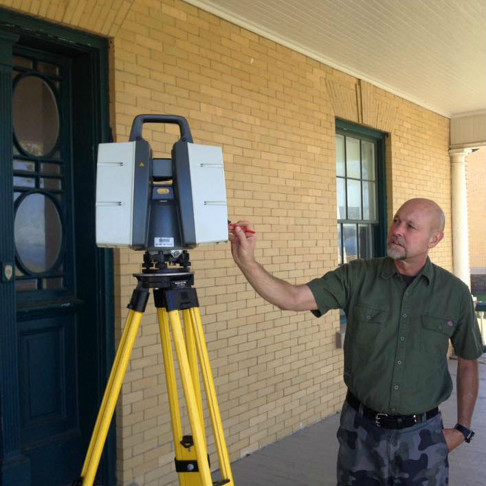
Dana Lockett is an architectural project manager with the National Parks Services Historic American Engineering Record in Washington, D.C. producing architectural and archival documentation of cultural resources. He holds a Bachelor’s of Architecture from Texas Tech University and has over twenty-six years of preservation experience with heritage documentation programs. Dana emphasizes digital surveying of engineering and industrial sites using measuring techniques such as terrestrial laser scanning (TLS) and photogrammetry, combined with computer-aided drafting or CAD, as well as 3D modeling.
So it’s a first for PreserveCast in the sense that we’re interviewing two people at once and they are both joining us from Washington, D.C. with the National Park Service. And as we normally do, we want to understand how you got into this field. So I’ll throw this question out to both of you, and whichever one of you wants can take it first, which is, how did you get involved in this? How did you come to history? How’d you get the bug?
[Catherine Lavoie] Well, I guess I’ll start. This is Catherine. So I spent a year as an intern for Maryland Historical Trust working on a historic site survey in the coal region of Western Maryland. And my then supervisor, Donna Ware, she had worked on a HABS summer team, and so she was raving about it, and she told me that I should check it out. So I did the following year. I applied and I spent a summer working for HABS in Kansas and then I ended up in the Washington office. And actually, it’s kind of an interesting point, that just about everybody who does work in our offices started out as a summer intern. So as I sometimes say when we get school student groups in here, “You, too, could be the chief of HABS. Just start on a summer program and work your way up.”
[NR] Start as an intern and they never let you go.
[CL] There you go! And never leave.
[NR] Okay, and Dana, how about yourself?
[DL] Yeah, it took me a little while to get the bug. I started out as an art major and then decided to go into architecture about a year later. And while I was attending Texas Tech University, the architecture program, one of my professors, John White, he was really heavily involved in running summer projects for the Historic American Building Survey. And he got some students together and said just to let us know that this program was available and out there for summer employment. Of course, the next summer I applied and got a position, and I went out to – this is the summer of 1987 – documented a railroad bridge over the Erie Canal in Ohio and then did it the next summer in Thurmond, West Virginia documenting a railway town, the depot, engine houses, and stuff like this and just kind of fell in love with it. And then after I graduated, I left the country for a while and then came back and applied directly to Washington D.C. position. And this was 1991, and I’ve been here ever since.
[NR] Wow. So both of you collectively have a considerable amount of experience with all of this. What should the average person know about HABS? How would you describe HABS, if someone off the street said, “I have no idea what you’re talking about. What exactly is HABS?” And either one of you can take this, whoever feels like they’re best suited for the job?
[CL] I’ll start with HABS and Dana can fill in with HAER, because it is different since HABS was created first as the very first federal preservation program. What you really need to know about HABS is about our collection. So our mission is to create an archive of America’s architectural heritage through the production of measured drawings, historical reports, and large-format photographs. But we did start in 1933 as a make-work program during the Depression, which is very interesting, but it was actually part of a larger movement. I think there was a growing sense that we were losing our vanishing architectural heritage and that we needed to somehow record and to keep that for future generations. And so, as the first federal preservation program, we really did lay the groundwork for a lot of the programs to come. I mean, we’re called the Historic American Building Survey, because we actually did get out there and do surveys and identify buildings that should be recorded. So we were creating surveys, and we created listings of these buildings, then documented about a third of them in that time. But today we still do a lot of documentation. One of our main goals, though, is also to try and create standard setting documentation, prototypes for new resources that need to be recorded, and also to field test new technologies and whatnot, which we’ll touch on later.
[NR] Yeah, absolutely. And, I guess, to pick a point there, you say documenting new types of resources. What would be an example of that? Where something that you’re beginning to document that maybe would surprise a listener? Or something that maybe even would surprise you if you told yourself 25 years ago that you would be documenting something like this?
[CL] Well, we just started, actually, the Historic Vehicle Admin- Historic Vehicle – ?
[DL] Association.
[CL] The Historic Vehicle Association came to us recently because they want to document the fifty most important cars in America, and they wanted us to help them develop a prototype for what drawings of cars should look like, how best to record that. And so we’re working with that. But, actually, I think that’s a perfect segue to turn this over to Dana because HAER grew from HABS for…
[DL] Yeah. So I think it was kind of the same realization in 1969 when the Historic American Engineering Record (HAER) was started. There was a realization that we were losing this technology and these these sites that have to do with our industrial heritage. And how do you save that or at least try to preserve some of it, when it was really disappearing really quickly? So that’s where HAER came in and started doing a similar process of the HABS documentation. Typical, like, elevations, sections, plans, but adding onto it a little bit more to decipher what was actually happening in these buildings, what processes were taking place. So that’s where the HAER side differs slightly from the HABS. We not only show the typical drawings that an architect would show of a building, but we also show the processes taking place inside them by doing different types of drawings. Not necessarily 3D, but like a 3D representation. So these usually would include a exploded metrics to show joinery, like in a bridge connection. So if the cords were coming together at a specific point, you would want to pinpoint exactly what made up that connection. And so to show everything, we would explode it out so you could see all the different elements within that connection.
[NR] So for Catherine’s point about vehicles, would it be HAER that is actually doing the vehicle documentation or setting that standard?
[DL] Correct. Yes. The typology that we’ve kind of set for the vehicles is a little different, and we’re not going into the specific machinery of the vehicles right now. We’re just doing kind of a plan, elevation, drawing set for them. That seems to be what they wanted, and it fits in our niche also about what the library would take as a record of it.
[NR] And then beyond HAER, there’s also sort of a third version, the third piece of documentation, which is HALS, correct?
[CL] Right.
[DL] Correct, and HALS was just a very recent entity that started in 2000. And kind of similarly, it has all of these same elements as the HABS and the HAER program, but it kind of expands on the landscape features within a specific site. So focusing not only on plan, but telling what each plant life is and calling that out in the drawing set so that there’s a record of those plant types within this plan. But also the histories are reflecting the design of the landscape and all of these different aspects that only apply to that particular approach.
[NR] So the way that you and Catherine are talking, it strikes me as you’re probably detail-oriented people. And that seems like what it would be – a requirement of doing this kind of documentation, particularly when you’re talking about, on the landscape level, documenting individual plants and how they’re interacting in the landscape. It sounds like extremely detailed work. I mean, could you give us a sense for how long – I mean, I know it’s different based on the size of a structure, but how long do you have or how long do you spend documenting a structure or a factory or a bridge? I mean, [can you] give me any sense for what kind of time involved we could kind of think about with a project like this?
[DL] Yeah, I think it definitely depends on the site and the resource that you’re working with. In general, we try to break– even if it’s a large project, such as Ellis Island – we try to break it down into smaller elements so that we’re focusing on a specific period of time, maybe three to six months of documentation, research to do the histories, and time to go out and take the photographs. So these all kind of have to coincide with not only access to the sites, but also weather conditions. So it can differ, but generally we try to make it fit into a three-to-six-month period.
[CL] We sort of have two tracks, because we have a summer recording program. We’ve been doing it for 60 years plus, so we bring students in in architectural history to work with us to create documentation, and they work on a 12-week schedule. So they have to produce their drawings within that time frame, even though Dana and I will spend lots of time afterwards editing their drawings, and reports, and whatnot, but that also is maybe a little more fast-tracked in some ways depending.
[DL] And now that we have some employees here, we have a group of employees with all of the programs now that can work year-round. So we do tend now to lengthen our projects and make them a little longer, since we have the manpower to put behind them.
[NR] So there’s work that is driven by, let’s say, a National Park Service site that has funding to document something like an Ellis Island, perhaps. But then there’s also a lot of your work is driven by the regulatory environment, section 106 of the National Historic Preservation Act, which some people may be familiar with, which says, “that if you’re going to invest federal dollars and there’s an impact on historic resources, you either have to avoid or you have to figure out a way to mitigate a negative impact on historic resources.” And a lot of times on the preservation side we see this idea that there should be at least HABS level documentation of historic resources. So do you get called in to document a fair amount of things right before they’re about to be lost? Does that happen pretty often, too?
[CL] We do that to some extent, but it’s usually proactive. We’re usually doing it because they may be anticipating work and they want to make sure they understand what’s important so they protect those resources. We generally don’t do mitigation. It’s usually handled through the regional offices and done by private sector consultants. However, all that mitigation comes through this office.
[NR] And it has to be done to your standard, right?
[CL] Yes, exactly right. So we provide a lot of advice, and guidance, and review for mitigation. But we generally don’t do mitigation, per se.
[NR] Okay. The podcast is focused on a couple different big themes. And one of them is this idea of the intersect of technology and preservation and how technology is changing historic preservation, and that has taken us down a lot of different paths. We talked with a gentleman in Montgomery County, who is looking at the future of autonomous self-driving vehicles and how that will impact our historic communities, which was eye-opening. We’ve also talked to folks who use drones to survey historic resources and then lasers. So there’s a lot of neat stuff out there.
It seems like you mentioned, Catherine, I think it was you that said you’re the first federal preservation program, which I think is something we should point out. This is the granddaddy of all preservation programs out there. And so has it been slow to adapt to this new technology and embrace it? What’s going on with HABS and technology? How is that happening?
[DL] Well, I’ll say something, but then Dana’s really the person who’s best equipped to answer the technical question about that, but we always are exploring new technologies. We’ve always tried to stay on the forefront of looking at new technologies, but we do have the Secretary of the Interior’s standards that guide us. So when we look at new technologies, we do it in the context of how the documentation needs to be created so that it will last for generations, and that’s one of the reasons why we’ve been criticized for not jumping into the digital world with both feet. But we certainly use digital cameras. We use laser scanning. I’ll let Dana talk better about that. Specifics.
[DL] Yes, we’ve been really pretty close to the forefront of most technologies that have been coming out. I know that photogrammetry has been around for a really long time, and I know this office was using it like –
[CL] In the 1960s.
[DL] In the 1960s – so way prior to my arrival – and now it’s becoming kind of resurgence again. And that is one of the new technologies that we’re using in our workflow, as well as terrestrial laser scanning. Our first project with using terrestrial laser scanning was started in 2002. Well, it was kind of a test because the technology was kind of available to the public in around 2000, and then we started kind of diving into it in 2002 to test it and see how it would work. And our very first project was the Statue of Liberty that we did with terrestrial laser scanning, so I feel like we were – and that was 2006 – so I feel like we were kind of on the precipice of doing that fairly early.
[NR] I think Catherine pointed out that everything that you do has to really stand this massive test of time, that you want this record to stand for a long period of time. What does that mean when it comes to digital resources? Do you have to print off a copy, or – I mean, how do you take a laser scan and make that stand the test of time? Because obviously the digital copy could be corrupted, or it could be lost, or you could not have the technology to open it. How does that work?
[CL] Yeah, that doesn’t work [laughter].
[DL] No. There’s lots of discussion now in the field of how do you preserve these laser scans digitally? And there are people that are doing it to some degree, but I don’t think there’s really a quantitative background of what the results are. We know that the documentation that we create is a hard copy and has to go to the Library of Congress, where it’s archived and has a shelf life of at least 500 years. Now I think with any digital data, they can’t guarantee that it will last more than five years. So we’re really struggling with, even though we’re using this data, how do we hang on onto it at least for a little while, so that it’s available in some way to whether we’re going to use it again to create drawings from or in some other capacity with the parks.
[NR] That’s interesting. So we’re going to take a quick break right here, and then we’re going to come right back and talk a little bit more about this issue and the standard of preserving things for 500 years. That’s tough. And so we want to hear more about that, and also we want to talk about perhaps what’s next? What kind of documentation could be on the horizon? And sort of your dreams of things that you could document or tools that could be used to document architectural resources moving forward. So we’ll be right back here on PreserveCast.
Maryland: Mini-America
[Stephen Israel] Man, I love Maryland sports. Dem O’s. Michael Phelps. We should make swimming the state sport.
[Margaret Pelta-Pauls] Actually, Steve, Maryland already has an individual state sport.
[SI] Oh, hey Margaret. Yeah, I know we’ve got lacrosse they got that one with the horses, right? What is that, again?
[MPP] It’s jousting.
[SI] What’s that all about?
[MPP] Well, Steve, jousting was named the state sport in 1962. In fact, Maryland was the first state to establish an official state sport.
[SI] Oh, that’s pretty cool, I guess, but why jousting?
[MPP] People have been jousting in Maryland for most of the time there has been a Maryland. In 1634, Cecil Calvert, the second Lord Baltimore, is understood to have hosted more traditional tournaments in Maryland. But the modern version really got going in 1839 when William Gilmore, the son of a wealthy land-owner, visited Scotland and saw jousting at an old castle that was part of a medieval revival celebration. The medieval culture around chivalry was in vogue in Britain at the time and for some that meant jousting. Of course, this was ring jousting. Different from medieval joust, competitors still charged on horseback with a lance, but instead of trying to knock an opponent down, they tried to use precision to catch hanging rings.
[SI] Oh, that ring thing sound fun, but it’s got to be hard to setup. Did people actually do that?
[MPP] Oh yeah. Gilmore came back to Maryland and hosted his first ring jousting tournament that year. It took a little while to build up, but other tournaments started popping up all around the state, especially after the Civil War. Jousting tournaments were popular as fund-raisers for community efforts and for Civil War memorials and they haven’t gone away. Last year was the 150th Annual Calvert County Jousting Tournament.
[SI] Wow! Thanks, Margaret. I guess I get how jousting ended up the state sport.
[MPP] Well, with Maryland history there’s always more to learn. But now we have to get back to see what Nick’s up to on PreserveCast.
Do you have questions? We may have answers. If at any point during this podcast you’ve thought of a question that you have for us or maybe one of our guests, we’d love to hear about it. You can send an email to podcast@presmd.org, and we’ll try and answer it right here on the air on the next episode of PreserveCast.
[NR] This is Nick Redding, and you’re listening to PreserveCast. We’re joined again today by Catherine Levoie and Dana Locket of the National Park Service with the HABS and HAER program. And we were talking before the break about how you take these new technologies and these really interesting and innovative resources, like laser scanning and photogrammetry, and how you turn that into something that can stand the test of time, and that can be archived, and has sort of a permanence to them. And I know Catherine wanted to jump in with a comment there, so I wanted to throw that back to Catherine as well.
[CL] Oh, thank you. Well, I just wanted to follow up on what Dana was saying so that you understand that we use laser scanning as a tool to create measured drawings. So we sort of push against the whole “scan-and-can movement,” as they say, that the idea that laser scans alone are documentation or can digitally preserve something. So we translate that data into CAD and then we create the measured drawings from those. Because, frankly, laser scans are very interesting. It’s great information, it’s very accurate, but it’s really only useful to professionals. You need expertise and lots of really expensive software to be able to use, even to view the data, let alone manipulate it. And so the drawings really are a really important interpretive tool. And if you’re going to be doing work on a building, if you’re a contractor or an architect, you really need that measured drawing.
[NR] So that’s interesting. So you’re taking the laser drawings and then actually turning that into or excuse me, you’re checking the laser scannings and then you’re turning that into the drawing itself, but not just stopping at the scan. Is that the same on the HAER side?
[DL] Yes, definitely is across the board. So we go out and we’ll laser scan a site using Trustwell laser scanner, but it’s virtually impossible to pick up 100 percent of a site using laser scanning alone. Inevitably, you have to add in hand measuring, maybe some photogrammetry to get really small details that the scanner won’t pick up. So you’re having to use all of these different methods to pick up everything about the site, and then you have to decipher all of that and process it into something that is readable by either a professional or a layperson that would be accessing these drawings at the Library of Congress.
So we’re usually taking these laser scans, if we’re going straight to 2D drawings, we take it into a CAD program, and we’re able to slice it up into different ways so that we can trace directly off of this point cloud or the photogrammetric 3D mesh model or a hand measured piece that we’re adding all together inside CAD to create a full comprehensive documentation of what is existing, what’s there. But then there’s also the option of taking this 3D laser scan and processing it into a 3D smart model. There’s all kinds of 3D models. You have this kind of dumb model that the laser scan puts out. You can turn that into a smart 3D parametric model, which just has a lot more information and allows you to take it to other deliverables from that. Or you have 3D mesh models, and there’s even surface models. So there’s all these different kinds of 3D representations.
And what’s the best way to represent that? It depends on the site. Sometimes a 2D drawing is all you need, and you can just trace it directly off of your information. But sometimes, a 3D model, for example, a 3D solid model, is better. For example, we had a site. It’s the NASA Field Laboratory out in Santa Susana, California. Very complicated towers where they strapped rocket engines to and fired them off to test them, made of all kinds of steel members, very complicated interior and exterior. Well, the best way that we found to create a drawing scent of those was to take the laser scan to a 3-D solid model and then convert those 3-D solid models into flat 2-D sections and elevations. It was easier to deal with the 3-D solid model than it would have been dealing totally with just the point cloud to get all of these finely-measured drawings from.
[NR] So it seems to me – just to kind of jump in here for a second – that it gets, to kind of boil it down, it gets really complicated really quickly. It’s not so easy as just to scan it and kind of move on from there. Obviously, you’re trying to get the best representation, and so that can take you in a lot of different ways. And I’m curious, though, you’re constrained by the – and not constrained, but you’re following, I should say, the Secretary of the Interior’s standards. There’s discussion within the preservation field about whether or not different components of those standards, and you’re talking about the documentation piece, needs to change, or if there are things that will need to be tweaked moving forward. I mean, any sense for that? Where is HABS on that? Are there things on there that you would like to see changed or that you think may have to change as we move forward? Or are we pretty confident and comfortable where we’re at?
[DL] I think it’s changing in all of our work, all three programs. What our normal deliverable is for the Library of Congress is changing some because of the data that we’re able to collect in the field with these new technologies is allowing us to kind of get extra things, and so we’re adding that information into these 2D drawings. And whether that’s a digital elevation model that we can download from satellite images or even photogrammetric data from drones that we can take and build maybe the landscape that we’re placing the building that we just laser-scanned into. So it is changing, and growing, and developing as we go along. And we’ve always felt that not only providing the Library of Congress deliverables, the hard copy archivable items, we’re very interested in giving the parks or the sponsors of our projects, whatever is going to help them explain the site and their resource and we find that the 3D models are great with that in many different ways. Sometimes we can give them a fly-through of the point cloud, which allows people to see it pretty clearly. It’s not super precise in the way it’s shown because of the nature of a point cloud. But then we can actually sometimes splice in the 3D solid modeling that we’ve done on top of the point cloud into those videos and explain a little bit more and maybe then even animate that so that we’re showing movement in a video, and then they – the site or the sponsor of the project – can actually post this on a website and show this to visitors or people that are interested.
[CL] Though on the flipside of that, one thing we are concerned about is: that’s the storage and the preservation of the laser scans. And we don’t really have the capacity to keep those kinds of records indefinitely. In fact, we’ve talked to the Library of Congress. They’re, at least at this point, unwilling to accept our digital data. Partly because they feel that the user group for something like laser scan, which is just professionals, is so small that they cannot justify the expense of storing those scans. And it is! It’s quite expensive. Laser scans and digital photography, they estimate the cost of storage at ten times that of capture. And that’s exactly what we’re finding out. So it’s one of my concerns as a preservation professional, that our dollars are going to be spent trying to maintain data that has to be routinely checked for degradation and upgraded, and that won’t have the money to create new documentation. I think it’s a real – it’s something that we are all going to have to think about in the future.
[NR] It’s interesting because it’s actually the same paradigm that preservationists are always confronted with which is we can save the building and we can fix it, but if we don’t have a long-term sustainable approach to utilizing it, then there’s no point in saving it,” right? So and it’s kind of the same point with documentation. Yes, we can document it using all of these fantastic resources. But if we don’t have a plan in place for how we’re going to host, and maintain the data, and have it, and make it available, then what’s the point of doing that? So it does create an interesting question. And I think it’s one that a lot of people who are beginning to embrace the technology perhaps aren’t thinking about. But definitely one worth thinking about. And I’m just curious, it just kind of came to me, which is have you guys ever experimented with printing off anything in 3D? Has that ever been tackled by HABS? I know it’s being done elsewhere. But do you guys do that?
[DL] But not for – only for fun.
[NR] Okay [laughter]
[DL] We had an employee who bought a 3D printer on his own. We’ve taken some of our 3D models and put them into his printer, and we printed them off. I think we’ve done a keystone that was at Ellis Island over one of the arches, like a carved face or a head.
[NR] Could you ever see that becoming, as the technology obviously advances, could you ever see that becoming a way of permanently preserving a component or a piece or is that just too far out there for us to think about at this point?
[CL] Well, we are using photogrammetry to document statuary. Lately, the National Capital Region folks came to us because they had some statues that were damaged. They were missing parts. And then in other cases where they had text panels that were no longer legible. And so they had a scan as a means of helping to create the model. So those parts could be replaced.
[DL] Yeah. And like in those situations with the text panels, they actually created a file that they could recreate that text with an engraving machine. So it was a digital file, computer file that would allow them to recreate that. So it’s kind of like a template. And then with the 3D printing, specifically with the statuary where, I think, that eventually you could print a hand that had broken off or re-sculpt a hand, a print it in 3D, and create a mold, and then you could actually do preservation work that way. Maybe this isn’t pertaining to what we would do exactly in our office, but definitely out there in the field of preservation.
[NR] Interesting. That’s pretty cool and pretty wild. So in the world of documentation, we have an interest, obviously being in Maryland, about resources here in the state, and Antietam has a lot of interest in it, a lot of historic resources out there… And I know that HABS has documented things there before. Were either of you involved in those projects or anything that you could tell us about how you document resources out there? Was it just structures, landscapes? What does it look like on a battlefield?
[CL] Sure. Well neither of us were involved directly in doing the fieldwork, but I do know about a lot of the work that was done there because we have done a lot of measuring and drawing of a lot of their farmsteads to provide baseline documentation that their maintenance staff and their craftsmen need to maintain and restore those sites. They have a really incredibly dedicated, engaged group of folks up there that are interested in preserving the buildings and making sure that it’s done right to ensure the accuracy and the integrity of the buildings for interpretation and other purposes.
And we’ve looked at the landscape a bit, too. In fact, I think one of the interesting sites that we documented there, in addition to the farmsteads, was the stone Observation Tower that was built in 1896 by the War Department, who maintained the battlefields before they were handed over to the Park Service. And they wanted to provide tourists and visitors a perspective from which they could view the battlefield because there isn’t any really super high natural feature, like a hill that you could get up on so that you could see the big picture. So they created this stone tower from which you can get a 360 degree view. It’s really kind of fun.
[NR] Well that’s pretty interesting. So let me ask you this, everyone that we have on PreserveCast, we don’t let them leave the podcast before they let us know their favorite, either, historic site or building that either they’ve worked on, or perhaps in your case that you’ve documented. And so we want to throw that out to both of you. Neither of you are safe from that question. So we’re going to make you have to tell us what your favorite historic site is. And this will be made public. [laughter]
[CL] Ooh, I mean, that is such a hard question because I feel like every time we get a new project, once you get into it and you start researching it, it becomes the most exciting thing. And we’ve done a lot of work – myself and a colleague of mine actually worked on the Maryland 100 for the Society of Architectural Historians. So we’ve tried to identify themes so we can make sure we represent Maryland through its architecture in a comprehensive way. So that’s been real exciting because Maryland has an incredibly rich history and historic architecture, as we all know, ranging from colonial buildings, Annapolis, our maritime culture transportation. We’ve got the B&O, [the] first railroad. We’ve got canals, the C&O. We’ve got the National Road and Urban Planning from Greenbelt to Columbia, Maryland, to even Mount Vernon Square in Baltimore, which is one of the greatest early nineteenth-century planning. So maybe if you really, really pushed me, I’m –
[NR] Well, you’ve done an excellent job of surveying the entire state just now. So that was really good.
[CL] I mean, that’s my way of saying, “I love it all.” But I guess one of the Maryland projects maybe that I did enjoy the most was writing a historical report for the Washington Monument in Mount Vernon Square in Baltimore, partly because I have an interest in George Washington as an iconic figure. But I was really proud to know that it was Marylanders and it was Baltimore citizens specifically who built the very first monument to George Washington. And, in fact, the first most significant monument this country has seen. Because we really didn’t start monument building really until the 20th century. Because early on when they first lobbied for a monument to George Washington, our government felt that it was not appropriate to build monuments, that it was not conducive to a democratic society. So it was the citizens of Baltimore that rallied to create the monument to Washington.
[NR] Yeah. That’s a pretty good answer. I like that one. Dana, where do you fall on this?
[DL] Yeah. I’m pretty similar to Catherine. There’s so many- and I kind of gauged these on how much I learn at a particular site that I’m working on. And the one that is, I think, my favorite for a couple of reasons because it’s very cool, it is very unusual, and it’s kind of a site that doesn’t really have a home. Not a stable home. And this was the Space Shuttle Discovery.
[NR] Oh, wow!
[DL] We documented it in 2011 by doing laser scans and so we got to climb all over it and feel the surface of it. It was just amazing to see all of the different elements that went into creating this orbital vehicle and just was crazy fun. Just seeing it and being around it, and learning about it. Not only were we actually documenting the vehicle itself, we were describing its takeoff, its landing sequence, so it’s the whole transportation system and how it went into space and returns.
[NR] Yeah. I recently had the opportunity to go to Mission Control in Houston and picked up the same space bug there and got that sense of, “Wow, we really did something powerful with our space efforts and reaching for the stars.” And getting to climb around on something like that I think would be pretty phenomenal. So I think that those were both excellent answers. George Washington and space shuttles [laughter], you really can’t go wrong with either of them.
So I want to thank both of you for joining us today. I think you gave us a great snapshot of what HABS does and the interesting interplay with technology and getting a sense for some of the great resources that you’ve documented in our state like Antietam and – it’s just been a lot of fun talking with both of you. I know sometimes it seems like the HABS work is sort of unsung work because you’re the hand and the mind behind these very detailed and complex drawings and people don’t know that, perhaps, you’re the one who did them. But I want to take this opportunity on behalf of the preservation community at least here in Maryland, to thank you for all the work that you’ve done to document these resources and for all the places that you’ve captured and are hopefully going to keep on in our memory at least for 500 years, if not longer. So thank you both for joining us. We loved having you on PreserveCast and keep up the good work.
[CL] Thank you. It was our pleasure.
[DL] Thank you, Nick.
Credits
You don’t need to open a history book to find us and available online from iTunes and their Google Play Store as well as our website: PresMD.org. This is PreserveCast.
This podcast was developed under a grant from the National Center for Preservation Technology and Training, a unit of the National Park Service. Its contents are the sole responsibility of Preservation Maryland and the Maryland Milestones Heritage Area and do not necessarily represent the official position or policies of the National Park Service or the National Center for Preservation Technology and Training.
This week’s episode was produced and engineered by Ben and Stephen Israel. Our executive producer is Aaron Marcavitch. Our theme music is performed by the band Pretty Gritty. You can learn more about them at their website: PrettyGrittyMusic.com, on Facebook, or on Twitter @PG_PrettyGritty.
To learn about Preservation Maryland or this week’s guests, visit: PreservationMaryland.org. While there, you can check out our blog and learn about what’s current in historic preservation. We’re also on Facebook, Instagram, Flickr, and Twitter @PreservationMD. And of course, a very special thank you to our listeners. Keep preserving!
Previous episode